Leica Cyclone MODEL is a powerful module providing a total solution for working with point clouds to create 2D and 3D deliverables. A versatile and complete tools set used by professionals in a vast array of industries and applications for civil, plant, architectural, BIM, forensics, heritage, and other types of projects.
Unmatched versatility and performance help make Leica Cyclone MODEL the industry’s most popular standalone software for analysing rich, laser scan data and converting the data into deliverables.
Among its advantages, Cyclone MODEL boasts powerful visualisation and point cloud navigation plus the industry’s most complete tool set. These tools cover a wide range of applications in engineering, construction, asset management, heritage, forensics, and other areas.
Cyclone MODEL provides unmatched office productivity, automating many time-consuming tasks and even letting multiple users work on the same data sets simultaneously – thanks to Cyclone’s Object/Database foundation. Finally, Cyclone MODEL reflects the data quality & accuracy-consciousness advantages that users worldwide expect from Leica Geosystems.
Features & benefits:
Scripting functionality
Direct import of Leica HDS and Leica Pegasus project data, including mobile trajectories and imagery
Direct import of DotProduct *.dp files
Batch import and auto image-to-scan alignment for iSTAR, Spheron, and Nodal Ninja external camera workflows
Advanced image-to-scan texture mapping options with complete HDR Tone Map Editor
Multiple, fast, convenient visualisation modes.
Fly Mode for smooth, 3D fly-through navigation, including 3D mouse support
Full support of publishing and reading of LGS (Leica Geosystems’ universal project files). LGS files are fully supported by all Leica Geosystems laser scanning / HDS software products. All your digital reality data, anywhere.
Support for BLK360 IR imagery, including per-point temperature picking
Support for Cyclone FIELD 360 pre-registered projects
Support for RTC360 Visual Inertial System (VIS) links
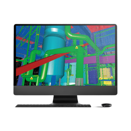
Plant & building tools include:
Best-fit modelling
Standard catalogue model fitting
Clash detection
Auto Pipe Finder and Pipe Run Finder to automatically find and fit cylinders
Civil & related tools include:
Breakline generation from feature coded templates
SmartPicks and Points on Grid tools
Virtual Surveyor data collector emulation
Extract contours, cross-sections, profiles
TIN/Mesh creation, including grid option
Calculate volumes, areas, and clearances